Cambrian Cave Registry

Registry History and Development
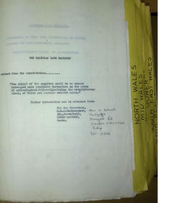
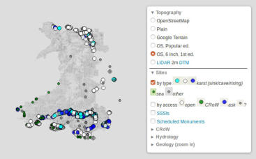
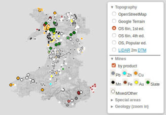
The Cambrian Cave Registry was initiated in 1966 long before the internet, personal computers and smart phones. Its aim was to record, index and make available information on the sites of speleological interest and the metalliferous mines of Wales and of certain related areas. The current format is an online database placed within the Caving Wales website which can be searched by cave name, by area of Wales, and by other features. There is also an interactive mapping tool to overlay cave and mine sites on maps of Wales. Originally the registry was a paper document, as typed, loose-leaf master copies, intended for placing into libraries, as shown in the photo left. There was also a postal information service based on a punched-card index. Incredibly, knitting needles were pushed through the punched out holes to select only those cards that met some specific search criteria. Each registry entry comprised a mixture of bibliographic references and field observations of NGR, description, and access information. Sites are now classified by morphology (Cave, Pothole, Sea Cave, Rock Shelter, Doline, Other) and hydrology (Sink, Rising, Active). Development was extensive during the 1970’s and 1980’s, but it then fell into a state of neglect and faltering restarts until a concentrated effort began in 2004 to transfer the hard copy Registry into a computerised database. This turned out to be extremely time consuming with almost all the 1200 entries having to be manually copied. In addition to the existing Registry data, a considerable number of new and additional sites were added from guidebooks and other cave data research projects, especially the Brecon Beacons National Park Black Mountain Survey Project. This provided a map-based register of caves and digs, mostly with entrance photographs, for several years inn the late 1990's. Covering eight areas (Black Mountain, Central Beacons, Eastern Beacons, North Wales, Gower, West Wales, South-east Wales and Mid-Wales) there were around 1400 entries by July 2008 when "Underground Wales" first went online, rising to 1877 entries by July 2014, and 1937 entries by January 2015. The online interface now allows entry via a search by any part of a name which has been recorded for an entrance or other feature of interest. English, Welsh, hybrids, and the common shorthand initials may be used; hyphens are ignored for the benefit of those who don't appreciate their meaning in Welsh orthography. Locations are also shown on a variety of maps with optional geological and hydrological information. The map below left shows Welsh cave locations on the Registry, while the map on the right shows disused mine sites of interest. (Click on the images to take you to the webpage)
Caving Wales