The sites below have been mentioned in earlier literature but have now
been quarried away, had their entrances filled, or the location of their entrances are
unknown.
Other sites wrongly termed 'caves' in some sources are also listed, such as mines or follies.
Barnewell Cave
- Lost cave
near Holywell Archaeological cave
An
archaeological cave near Holywell where bones of mammals were found. Although briefly described in early literature, its location was not given. Recent research by Andrew Williams of
Holywell suggests that this cave could be White Quarry Cave No 7, although without evidence, its location may never be confirmed.
The first reference to this cave (and the lost Grange Farm Cave, below) can be found in "Caves & Caving" 1937, which gives no details of location, but simply states: "Barnewell Cave, Holywell. Museum of Stoneyhurst College, Lancashire:- Mammal remains, collected by the Rev. George Pollen, about 1897" (See PDF download at the very bottom of this page). Several requests in recent years for information on the bone collection at Stoneyhurst College have been unsuccessful.
The only other reference is by J. Wilfrid Jackson of Manchester Museum, in British Caving 1953......
“
Two
caves at Holywell, Flintshire, have yielded animal remains. In one,
known as Grange Farm Cave, the remains of hyaena and rhinoceros were
found; and in the other, known as Barnewell Cave, mammal bones were met
with”.
----------------------------------------------------------------------------------------------------------------------
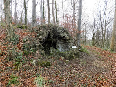
Big Wood Cave
- A folly
SJ16786877 Nannerch
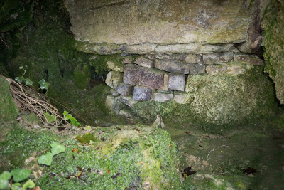
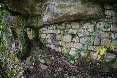
Not a cave at all, but a folly in the shape of an igloo, about 2m in diameter.
The igloo is made from stones encrusted with tufa deposits
probably originating from Afon Wen (t
ufa being a form of limestone formed by precipitation).
The entrance has partially collapsed.
According
to the current land-owner, the folly was created about
200 years ago.
A second similar, but better-preserved folly lies in the grounds of the same property to the south of Penbedw house.
(pers. comm. with both son and father in 2012).
Erroneously named as "cave" on some Ordnance Survey maps since at least 1912.
Erroneously re-named by CPAT in 2009 as Penbedw Park Cave (CPAT 'Report 980').
Access:
Prior permission must be sought from Penbedw Estate..... although visitors who have obtained land-owners prior consent should be prepared for the
game-keepers' unbridled wrath!
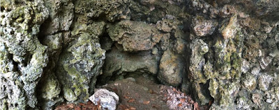
Big Wood "Cave" 2012
Showing the man-made internal tufa block construction
-----------------------------------------------------------------------------------------------------------------------------
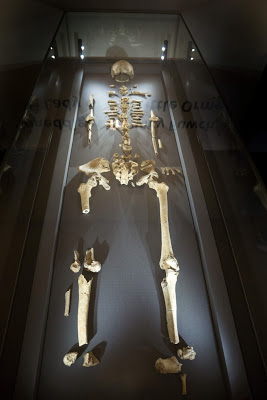
Blodwen's Fissure
Lost - quarried away Approx. SH817825 Little Orme Archaeological
Little Orme's Head Quarry
An archaeological cave or fissure quarried away in the 1890s or 1900s. The fissure contained the skeleton of which became known as Blodwen who lived around 4,720 years ago.
Who was Blodwen?
In 2016
Alicia H. R. Enston
at Bangor University produced a dissertation entitled
"Can Blodwen of North Wales Change the Common Perception
of Neolithic Burial Practices in Britain?" This pulls together the few reports on Blodwen and provides information based upon analysis of the bones, which show that Blodwen was about 5 feet in height, of robust stature and was between fifty-four and sixty-three years old when she died. The evidence suggests that Blodwen was suffering from cancer which had spread through much of her body. Finding cancer in prehistoric human remains is fairly rare, as they typically died at ages when they far less likely to develop the disease.
The evidence further suggests that Blodwen was suffering from arthritis the spine and right knee and had gum disease.
Oxford University carried out isotope work to discover Blodwen’s diet but found that she was a meat eater, and not fish as might have been expected living so close to the coast.
It is not known if Blodwen was placed in the fissure or if she had some kind of accident, but Enston’s dissertation suggests that Blodwen would have been unlikely to have been active enough at this time in her life to have died in an area away from her community; let alone have enough energy to walk along the Little Orme with the chance of falling into a crevice accidentally.
A short mention of the discovery of this cave/fissure was made in 1925:
"In
a quarry on the north-east slope of the hill, when a boring was made in
November 1900, a cavity was reached, circular and about 4 feet in
diameter; the sides and top were smooth. It was almost filled with sand,
in which were found fragments of flint implements".
(Source: The
Proceedings of the Llandudno, Colwyn Bay and District Field Club
1924-25, page 119).
More information but a conflicting date are provided here:
In
1891, a quarry working the east side of Llandudno's Little Orme broke
into a clay-filled fissure. In the fissure were found human and animal
remains and a more recent bronze spear-hear. The human bones were from a
female now known as 'Blodwen'. The quarry owners (Joseph and his son
Robert Storey) came from Bacup in Lancashire, and handed the remains
over to Bacup Museum, where they lay for a century.
Carbon
dating confirms that Blodwen was alive 4,720 +/-50 years ago in
Neolithic times. She was about five feet tall and of fairly robust
stature and died between the ages of 54 and 63. Work by Manchester
Museum discovered that she had cancerous lesions to her skull and pelvis
and degenerative arthritus of the spine and right knee.
(Source: "The Lady of the Little Orme
" 1997 by Kenneth Dribble)
In 2014 Blodwen was eventually returned to the area as a gift from Bacup Museum to Llandudno Museum where she now lies.
Blodwen at Llandudno Museum in 2016
----------------------------------------------------------------------------------------------------------------------------
Boot Cave
- A mine passage
SJ069815 ? Meliden
Mentioned in some early cave guides.
Not a cave, but a short descending Mine level near Meliden, Prestatyn.
Ended at a blockage of boulders and leaves when visited by the writer in the 1970s.
----------------------------------------------------------------------------------------------------------------------------
Bryn Euryn Quarry Cave - Lost - Quarried away
Llandulas Archaeological cave
Reported to have been quarried away and 'probably near Llandulas Quarry', Abergele.
An archaeological cave yielding ‘a few flints’ (Transactions of the Cave Research Group, Vol. 12, No. 2, 1970).
Not
to be confused with an archaeological cave on the Little Orme, also at a
quarry named as Bryn Euryn, where 'Blodwen's' remains were found.
Listed on this site as Little Orme Fissure (see below).
--------------------------------------------------------------------------------------------------------------------------
Caerwys Caves pothole - Filled by landowner
Located within a few metres of Caerwys Caves. A 12 foot deep vertical pot blocked with clay at its base, excavated by cavers in the 1960s. Filled by the landowner to ensure public safety in the late 1970s. No trace can now be found (2016).
-------------------------------------------------------------------------------------------------------------------------
Cefn Mawr Hall Cave
- Lost - Seen only by miners
SJ203629 approx. Cadole
A large open rift formed along a north-south fault found by miners in the village of Cadole near Mold.
Not
seen by cavers but stated in early mine reports to be about 30m in
height. It is likely to have been formed along a north-south fault or
'cross-course' where semi-fossilised tree trunks were found by miners at
depth below the surface.
In
woods close to where Cefn Mawr Hall once stood (demolished in the late
70s), or 100 metres or so northwest of the Colomendy Arms. It's not
clear from the mine reports which workings connected with this cave.
--------------------------------------------------------------------------------------------------------------------------
Ceiriog Cave, Upper
- Entrance filled
Length 53m
SJ249366
Chirk
Although named Upper Ceiriog Cave, it lies 2km south-west of Lower Ceiriog Cave.
A cave with archaeological potential, whose entrance appears to have been lost as a result of tipping by the landowner.
The entrance lies somewhere in a small old quarry, but w
hen visited by the writer in 2018, no trace of the entrance was found.
Primary sources describe the cave as:
A
crawl over red mud opens into the side of a water-worn passage 2m wide x
1m high. The floor contains remains of stalagmite bosses and the ceiling is
covered in a mass of straw stalactites and some helictites. The cave
ends at a low bedding plane which could be extended by digging as "it appears to widen out beyond the constriction".
First recorded in 1907 by E. A. Baker and H. E. Balch in 'The Netherworld of Mendip' (page 133).
Entrance
re-excavated in 1948 by J. Pierce, W. Day, W.S. Davies and N. Simmons
of the Offa Field Club, and resealed on farmers instructions.
Entrance
re-excavated in 1962 by Shropshire Caving & Mining Club, the Cave
Research Group and the South Wales Caving Club and again resealed on
farmers instructions.
Many thanks to D.H.Adams for the above first-hand information (see Bibliography page).
The
landowner in 1948 and 1962 was not kindly towards visitors. Things
today may have improved. If anyone has any further information, kindly
let this website know.
Head for the grid reference above, and the minor quarry workings can easily be seen from the road.
Shropshire Mining Club Account No. 9 (1972) describes the cave as being "north of the road above the farm called Starlings Castle, two miles north west of Selattyn".
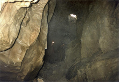
Cave entrance Photo: Netherworld of Mendip (1907) by Baker & Balch
--------------------------------------------------------------------------------------------------------------------------
Clwyd Forest Cave - A non-existent cave - Claimed to lie at SJ198605 Maeshafn
In attempting to pin-point Orchid Cave near Maeshafn, two
site visits by CPAT resulted in two different grid
references. Compounding the error, they named these as 'Orchid Cave 1'
and 'Orchid Cave 2'. This has now been corrected in the Historic
Environment Record (HER) to just the one 'Orchid Cave'. However,
because CPAT cannot remove a faulty record once it has been created (pers. comm Frances Lynch of CPAT),
they have applied a new (April 2012) name of 'Clwyd Forest Cave' (PRN
34750) to the non-existent 'Orchid Cave 2'. Hard to believe, but true!
--------------------------------------------------------------------------------------------------------------------------
Coed Marl Hall Caves - No cave remaining SH8013178621 Llandudno Junction
'Caves' lying in woodland once the property of Marl Hall on the outskirts of Llandudno Junction.
An archaeological report into the woods area was carried out in 2002 by Engineering Archaeological Services Ltd., entitled "Coed Marl Hall, Esgryn - Archaeological Assessment". Within the report three cave sites are mentioned, the main site being described thus: "By far the largest (cave) was PRN 16722. This appeared to be a partial longitudinal section through the cave, revealed either through quarrying or by the natural collapse of the rock face" (see section 5.1). The report then describes the deposits found.
The other two cave sites are described as showing either flow marks on one wall or flowstone deposits.
Although what remains may suggest the one-time presence of caves, no passage appears to exist today. They cannot therefore be included as caves on this website.
The report was kindly supplied to this website by Ian Brooks of Engineering Archaeological Services Ltd.
Park at the small public car park at the south-east corner of the wood, then walk back up the road for about 80 metres. Then take the only minor footpath up into the woods. The 'cave' can be found overlooking a very small old quarry and lies about 30m from the eastern boundary wall. Coed Marl Hall is managed by The Woodland Trust and open to the public.
'Cave' showing the "Indurated breccia" described in the report
--------------------------------------------------------------------------------------------------------------------------
Coppy Farm Cave No. 2:
- Lost cave - entrance blocked
(Cave No 1:
SJ0427666788
+/-9ft) Denbigh
Situated between Coppy Farm Caves 1 and 2.
When
visited by the writer in the 1970s, it was merely a short crawl
partially blocked by boulders, almost midway between Caves 1 & 2. The gentle curve of the passage roof suggested a larger passage blocked by deposits.
When
visited in 2013, no trace of the entrance could be found. It may lie
below a rough track created by the farmer leading diagonally up to the
hillside above.
Described
in the 1970s as:
"Mid-way along the outcrop almost behind a pair of large trees" . The trees appear to have been removed.
-------------------------------------------------------------------------------------------------------------------------
Dyserth Quarry Cave
- Quarried away
SJ063788 Dyserth
A short cave exposed by quarrying (but now gone) was found in 1961 by Shropshire Mining Club:
"Permission was gained from Mr. Evans, Manager of Hobbs Quarries, Dyserth, to visit a new cave on the quarry face. A descent of 50ft was made down the crumbly 300ft face to gain entrance to the cave. This was well worth while as it was extremely beautiful. It went in for 40ft to a terminal fall of rock caused by quarry blasting, the passage was roughly 5’ high x 4’ wide except for one short crawl. The first part of the passage was incredibly beautiful containing every imaginable formation of stalactites, stalagmites, rimstone pools, cave pearls, crystal formations, eccentric stalactites, helectites and stalcurtains. The last part of the cave was sadly damaged by nearby blasting and not so well preserved. There is the possibility of further extension as quarrying is continued. A large quantity of good samples of stal formations due to be destroyed were removed for preservation in the Club Room. A more detailed report can be obtained from the Club".
Source: Shropshire Mining Club yearbook 1961-62, page 35. It is available online: http://www.shropshirecmc.org.uk/yearbooks/SMC_Year_Book_1961-62_w.pdf
------------------------------------------------------------------------------------------------------------------------
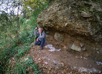
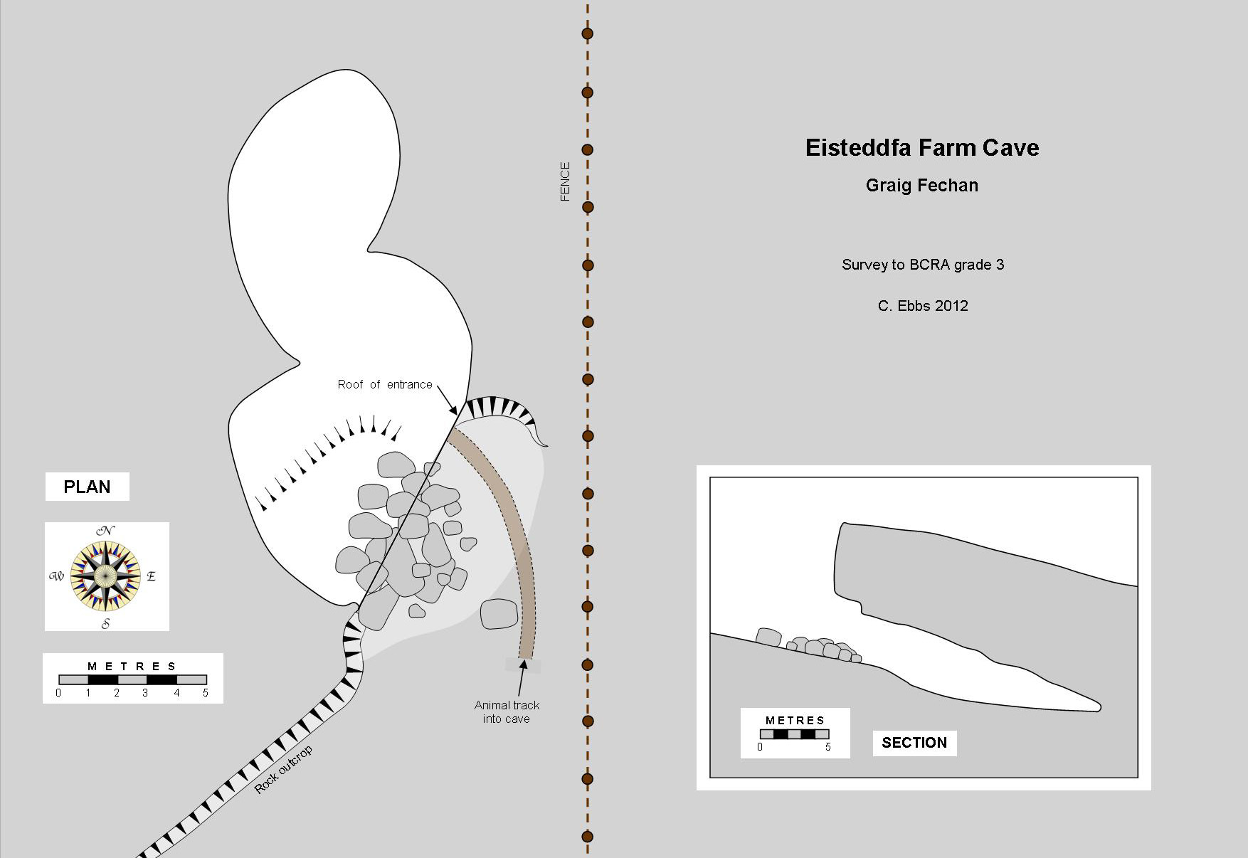
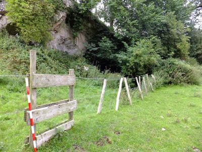
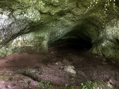
Eisteddfa Farm Cave
- Mine workings
SJ1479655580 (+/-15ft)
Graig Fechan, Ruthin
A large entrance measures 5m in height by 8m in width;
the site is basically one large chamber descending to an almost horizontal floor at the end, some 15m from the entrance.
Although created by mining, the site is described as a "cave" by archaeologists
(CPAT 'Report 980' 2009).
Animal
bones including sheep and roe deer (pers. comm John Blore 2012) lie on the earth floor of the
lower section, although these are recent and of no archaeological
interest.
In 2012, cattle were using the mine as a shelter.
The roof and walls display countless man-made linear markings including some later shot-holes left after blasting.
Iron residues visible in various places, and the abundance
of man-made pick marks, leave little doubt of the sites
mining origins.
Ancient mining expert Andy Lewis has kindly provided the following comments:
"The
iron pick marks obviously indicate there has been prospecting for some
mineral. Judging by the shape of the passage, lack of mineral vein and
iron staining, I would suspect the deposit could be a secondary infill
feature of a solution pocket in the limestone/calcareous sandstone.
There are similar deposits on Moel Hiraddug where cobalt and nickel
bearing iron/manganese ores are found infilling older solution pockets
and cave passage. I do not think the site is prehistoric, more likely
18-19th century would be my guess".
Archaeological:
PRN: 24310
The Historic Environment Record describes the site as: "Cave site recorded during Clwydian Range Upland Survey in 1996/7"
(CPAT Report 980, 2009).
CLICK IMAGE TO ENLARGE
View towards the large entrance, partially obscured by vegetation
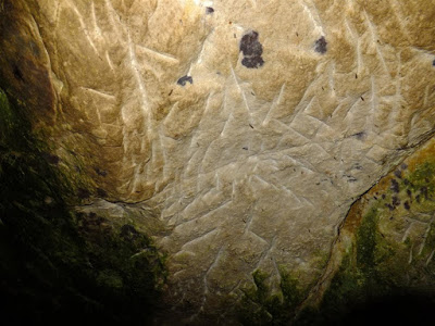
View from just inside the entrance. Note the 1 metre ranging pole for scale
Miners pick marks covering the roof
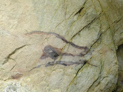
Iron staining at the cave entrance giving the appearance of early cave painting
------------------------------------------------------------------------------------------------------------------------
Fish Cave
- Mine passage
SJ069816 ? Prestatyn
Not a cave, but mine workings in the hillside overlooking Prestatyn.
An
adit can be followed for a couple of hundred metres to a flooded stope.
A second entrance on the hillside above (requiring tackle) provides a
short through-trip requiring tackle.
-------------------------------------------------------------------------------------------------------------------------
Grange Farm Cave
- Lost cave - location unknown
SJ172762
? Holywell Archaeological (animal only)
Not to be confused with the nearby Grange Caverns, a pillar-and-stall stone mine about 150 years of age.
It
seems that the location of this cave has been lost for many years. Although
the bones found here are said to reside at Stonyhurst College,
Clitheroe, repeated requests for information have failed to produce any response from the college.
Research in about 2011 by Andrew Williams of Carmel, Holywell may have located
the site, but access difficulties have prevented Andrew from entering the
cave. He does however describe the entrance as being of stooping size, adding:
"The entrance lies below a rock overhang in a small dry valley not far from the farm".
The first reference to this cave (and the lost Barnewell Cave above) was in "Caves & Caving" 1937, which gives no details of location.
The only other reference is by J. Wilfrid Jackson of Manchester Museum, in British Caving 1953......
“
Two
caves at Holywell, Flintshire, have yielded animal remains. In one,
known as Grange Farm Cave, the remains of hyaena and rhinoceros were
found; and in the other, known as Barnewell Cave, mammal bones were met
with”.
P
ermission and directions are needed from the farmer at Grange Farm, although it is understood that this is unlikely to be granted. If anyone is granted permission to locate and enter the cave, would they kindly provide a description?
-------------------------------------------------------------------------------------------------------------------------
Gwaenysgor Cave
, Lower
- Filled with sewage
'Upper Cave': SJ0802680421 +/-14ft
Gwaenysgor Archaeological
Gwaenysgor Cave comprised an 'Upper Cave' and 'Lower Cave'. The lower cave has now been completely filled with untreated sewage.
This badly neglected archaeological cave yielded human remains, flints and
charcoal, together with animal remains at least 12,000 years of age.
'Harrison's
Entrance' (after the miner who discovered it in 1885) was a shallow
vertical shaft which happened to break into a cave where bones were found in a
roomy chamber, originally called the 'Lower Cave'. The shaft
(originally 4m from surface to floor of chamber) currently has a
triangular cast-iron inspection cover fitted into a concrete cap, below
which a fixed ladder gave access to the chamber. Unfortunately this half of the cave has been used as a septic tank by Welsh Water for the last 40 years and is now filled.
For a full description of the cave with survey, see Gwaenysgor Cave on page 4.
All
North Wales' professional archaeological bodies ignored the pollution
that was destroying the 'lower cave' below Harrison's Entrance. It was
first brought to the attention of archaeologists in a published paper by Valdemar & Jones
in 1970. In 1979, an officer of CPAT was told of the problem by the
landowner during a site visit (CPAT site visit record
PRN 102239
),
but no attempt was made to inspect the damage below Harrisons Entrance.
Examining the wrong entrance, the CPAT record card states: "We saw no obvious signs of this (pollution). It may well have seeped away. It is a threat for urgent action". CPAT however, ignored their own advice, as the problem was allowed to continue.
In
the 1980s this writer raised the issue with Welsh Water, CADW, CPAT,
The National Museum of Wales and Clwyd County Council, but none were
willing to act.
CPAT
made official visits to the cave in 1979, 1988, 1993 and 2009, but on
all occasions the 'Lower Cave' below Harrison's Entrance
was not explored internally
. Hence little wonder they "saw no obvious signs" of sewage pollution.
The damage could have been minimised
by designating the site a Scheduled Ancient Monument (as the cave was clearly under threat)
if CPAT or Cadw had taken the matter seriously rather than simply relying upon unacceptably poor field reports.
--------------------------------------------------------------------------------------------------------------------------
------------------------------------------------------------------------------------------------------------------------
Llanarmon Quarry Cave
- Lost cave - quarried away
SJ19015744 Llanarmon-yn-ial
A 25m long cave found in 1973 by NWCC half-way up the east face
of the now disused Pistyll Gwyn Quarry at Llanarmon-yn-ial. "A small
entrance, then a roomy passage which descends steeply for 10m to a hole
at floor level in the north wall. This crawl passage continues for a
further 15m to where the passage is half silted with clay. An easy dig." (Source: writers diary Feb. 1974).
The cave has since been quarried away or its entrance lost under waste rock.
The lost entrance area has been thoroughly searched for (including looking for melt patches in snow), but without success.
-----------------------------------------------------------------------------------------------------------------------
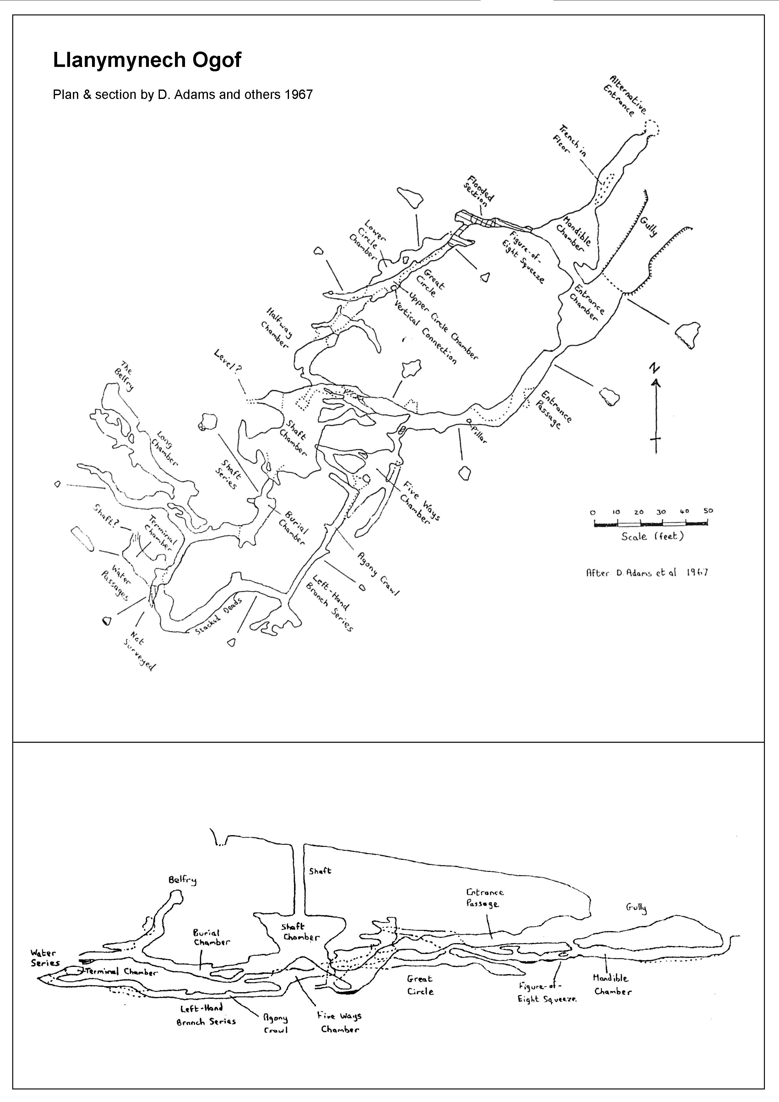
Llanymynech Ogof - Mine workings
Length: About 350 metres
NGR: SJ2657222195 +/-12ft
Shropshire (just)
Also called ‘The Ogof’
CLICK TO ENLARGE Click BACK button to return to this page
Survey supplied courtesy of Shropshire Caving & Mining Club
The site is located very close to the English-Welsh border, lying just outside Wales. Although the Welsh term for ‘cave’ is used in the name, the site is entirely comprised of mine workings.
The mine consists of several chambers connected by a series of passages which offer two or three round trips.
Llanymynych Ogof has a long, but sporadic history, dating originally it is thought, to pre-Roman times. It was later worked by the Romans, then in Medieval and post-Medieval times, then lastly in the 1800s when minor work was responsible for the creation of a small shaft, sunk from surface.
Various deliberate burials have been unearthed from within the mine, the latest by a metal detectorist in 2012. This led to C14 testing by the police, of the skull of a 1 or 2 year old dated to 1750 to 1800.
Being close to an ancient hill fort, the mine lies within the boundary of a Scheduled Ancient Monument.
Directions:
Drive up from the main road following the signs for the Golf Club. Before passing through the gate to enter the course itself, park at the small area off to the left. At the gate, take the public footpath off to the right. This hugs the hedge on your left until, after about 100 yards, the hedge boundary direction bends to the right. The footpath continues straight ahead, crossing the green (a marker post can be seen half way across). Another post indicated where the path enters the woods almost opposite. Take this path for about 10 metres and the mine entrance is just on your right, overlooking the green.
Sources:
A thoroughly researched article by members of Shropshire Mining Club:
http://www.llanymynech.org.uk/ll-ech_ogof.HTM
CPAT Report No.1407 (2016): http://orapweb.rcahms.gov.uk/coflein/6/652254.PDF
CPAT Report No.1166 (2012): covering Llanymynych Hill: http://walesher1974.org/herumd.php?linktable=her_source1_link&group=CPAT&level=3&docid=301366168
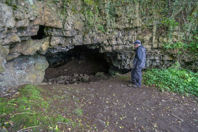
The entrance, lying just 20 metres from green No 7 on the golf course
The "entrance passage"
Approaching "shaft chamber"
----------------------------------------------------------------------------------------------------------------------
Llechryd Cave - Non-cave: A fault in the rock strata with no cave development
SJ00646843
Wrongly termed as 'cave' by CPAT in their "Tir Gofal Assessment" (2000).
Their report states "Observed from a distance. Cave appears to be in S side of river which is formed by a steep gorge (sic). The cave may contain important archaeological, and/or environmental deposits".
Although the site appears to be a cave of some sort when viewed from the footpath above, it is merely a feature of the rock strata (composed of mudstone, siltstone or sandstone) where a north-south fault crosses the River Asa.
Another point above this fault and a little to the left, may also appear as a 'cave', but is not.
A public footpath leads from the Henllan-Llechryd road directly past the heavily wooded gorge: After crossing the first field then going through a farm gate, take the stile off to the left. This leads after about 60 metres to the only point where it's possible to scramble down on the left. Access down to the stream is difficult, and is best attempted in the winter when undergrowth is at a minimum. It involves zig-zagging to descend the gorge, first downstream, then upstream following a tortuous route.
The site is mentioned on this website, to warn anyone interested, that as the site is neither cave nor mine, it is not worth the effort.
---------------------------------------------------------------------------------------------------------------------
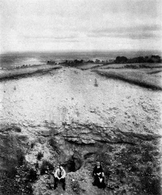
Minera Cave
- Lost cave - quarried away?
Perhaps
SJ255520 approx (source: CAPRA) Gwynfryn Archaeological cave
Human
remains of one person were found here in 1904. Possibly quarried away.
(see Ogof Hen Ddyn which lies very close to this NGR).
Thought to be a little to the west of Ogof Dydd Byraf.
Blasting operations early in 1904 revealed a cave "close to the river Clywedog" containing the skeleton of a man and other bones. Those bones which were not taken by the workmen and lost, were taken for further investigation by a Mr. Pringle of the British Museum who happened to be in Wrexham on a visit. They were subsequently examined by E. T. Newton of the Geological Museum, Jermyn Street, London, who confirmed that they were of prehistoric age. They were eventually returned to Mr Lewis at the Minera Limeworks. "The cave has now ceased to exist".
Source: "Minera" (1964) by Glyn Davies
-----------------------------------------------------------------------------------------------------------------------
Minera Quarry Cave
- Lost cave - quarried away?
perhaps
SJ254520 approx. Gwynfryn
A large cave broken into by quarrying is described in detail by Thomas Ruddy. The account mentions that 'the whole cave covered nearly two acres'
and contained many formations. Several large chambers or passages are
also described. The entrance may have been quarried away but it is
likely that much of the cave remains. Its position is not known despite
strenuous efforts by cavers.
The account by Thomas Ruddy is copied below..........
The Discovery of the Minera Quarry Cave
June 1892
P
ublished in Bygones Relating to Wales and the Border Counties 1891-1893 (pages 369-370)
.............. I was taken to the cave. The entrance to it was anything but inviting,
but having put on overalls I followed the guide and Mr.Lewis into a
hole, something resembling a fox’s earth. I had to lie down on my right
side and drag myself head first down a slope with scarcely enough room
to wriggle through. After going a few yards in this fashion I got into a
long narrow passage where I could nearly stand upright. Each of us had a
lighted candle which gave us a good light.
I
was soon conducted into a wide passage where there was plenty of room
to stand upright; and from this large passage into a large, roomy space,
from 40 to 60 feet in length by about 15 feet in width, and over 20
feet in height. The floor was very uneven and deeply covered with damp
clay, which made walking very difficult. A great part of the floor was
also covered with a thick stalagmite crust, some stalagmites rising like
pillars from the floor to the height of from 6 inches to nearly two
feet, and being from four to six inches in diameter. Some good
stalactites were hanging from the roof like icicles, some were in the
form of cylindrical tubes, nearly half a yard in length, and not more
than a quarter of an inch in diameter, and composed of clear transparent
calcite. Hundreds of the cylindrical tubes had fallen from the roof on
to the floor, and were embedded firmly in the stalagmite crust.
I
was next conducted into a long and wide chamber with a high roof, but
to get to it I had to crawl on hands and knees over the damp clayey
floor. The same stalactites and stalagmites were to be seen and the
walls of rock were much encrusted with a stalactitic crust. We returned
to the first large passage, and by crawling on our hands and knees again
we got into another large space with the floor sloping much upwards,
and having a very high roof. The floor was thickly covered with
stalagmite for the greater part, and there were some beautiful
stalactites and pillars of stalagmite.
From
this I followed my guide up a narrow passage on hands and knees again;
it was like going up a sloping flue until we got into a rough wide space
with much broken rock, which evidently had fallen from the roof; the
roof was very high and uneven. The floor was partly covered with the
usual stalagmitic crusts, and a small stream of water ran over a
gravelly bed in one part of it.
I
observed several small openings leading away from the principal
chambers, but they were too small for anyone to explore them. It is
supposed that the whole cave covered nearly two acres; it was laborious
work exploring it, and our heads received several hard bumps before we
got out again. The cave bears the impress of great
antiquity and its proper exploration might lead to important scientific
results. At present there is nothing to show that it had ever been
explored by man until its discovery about two months ago. Some of the stalagmites are like pillars of alabaster, but most of the best have been carried off (August 24th 1892).
Notes
-
The above report was re-published October 1st 1965 by J.N.S.Schofield of the Wrexham Caving Club and it has here been re-typed from that source.
-
The dashes on the first line infer that the account is only an extract.
--------------------------------------------------------------------------------------------------------------------------
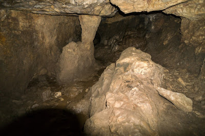
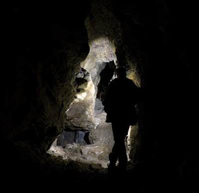
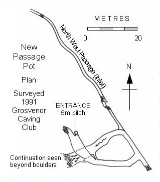
New Passage Pot
- Lost cave - Entrance blocked by quarrying
SJ251517 approx. Length: 150m+ Gwynfryn
Discovered in 1991 by GCC.
1991 description: A body-sized entrance in a vertical rock face opened over a pitch of 5m in a chamber 4m x 4m x 10m high. A 2m square passage led off east to a T-junction.
To the right lowered to a crawl becoming too tight. To the left the
passage descended and spiralled downwards before running west where it
was blocked by fallen slabs. A small inlet rift passage ran north-west
under the quarry floor until a few boulders barred progress, but was
seen to be open beyond. The entrance to this cave was quarried away
before it was fully explored, hence it remains a site with much potential.
The cave remains but the position of the current
entrance lies in the quarry floor and is now covered by large unstable blocks where a draught can
sometimes be felt. It's location can be seen as a melt patch in snowy conditions.
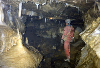
New Passage Pot: Two cavers standing below the entrance
New Passage Pot: The T-junction shown at bottom right on plan above
------------------------------------------------------------------------------------------------------------------------
Ogof-y-Gwynt
- Lost cave - quarried away
Gwynfryn
A short draughting cave in Minera quarry but now quarried away. First found in 1991 by GCC.
-------------------------------------------------------------------------------------------------------------------------
Penbedw Park Cave - A folly
Correct documented name is Big Wood Cave
One of two follies or igloos in Penbedw Park estate constructed of tufa blocks.
Incorrectly named by CPAT in 2009.
For details, s
ee entry above under Big Wood Cave.
-------------------------------------------------------------------------------------------------------------------------
Picton Mine Cavern
- Lost - Seen only by miners
SJ177756 approx. Brynford
"In
the Picton Mine a cavern full of water was cut into with so little
warning that the miners barely escaped with their lives. The water
disappeared in a short time, but St. Winifreds Well was temporarily
discoloured." (Bernard Smith, 1921).
-------------------------------------------------------------------------------------------------------------------------
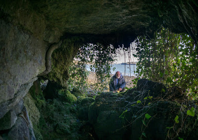
Plas Newydd Caves
- An erosional rock-shelter?
SH521698 Anglesey
Plas Newydd is a fine period property besides the Menai Straight, Anglesey. After the wooden naval training ship H.M.S. Conway ran aground in the Menai Straight the 1950s, the Marquis of Anglesey opened half of Plas Newydd as a shore base for the cadets. The writer spent three years as a trainee officer here, learning the ropes. Plas Newydd is now owned by the National Trust.
In 2015 the Trust built a modern heating system extracting heat from sea water. During this work, an 'archaeological watching brief' was carried out. This identifies 'at least two caves' and tufa formation at high water mark along the Menai Straight. The description is copied here......
“The pump house occupies a
section of the marine walk where the cliff follows a slight concaved
plan. The origins of this form is uncertain, however the presence of a
series of caves to the north and the presence of what appears to be a
flowstone floor running under the line of the cliff to the south
suggests the possibility that the slight embayment is the result of a
collapsed cave. There are at least two caves immediately to the north of
the pump house and a surviving pillar of indurated sediment which has
the appearance of having been cave sediment. The caves have been partly
blocked with rough stone walling, however there is sufficient evidence
to suggest that the caves extend behind the walling, although their full
extent is unknown”.
A visit to the site was made by this website in 2016. From a cavers perspective, it appears the ‘caves’ may only be the result of coastal erosion. The calcium-rich waters creating the tufa upon evaporation, appear to originate from seepages higher in the rock-face above.
At the moment therefore, the location cannot be included as a cave or caves on this website.
The possible 'flowstone floor' is certainly of interest, and does suggest that more work needs to be done at this site.
Although the stone-walling built within the overhang, gives the impression that the ‘cave’ may continue behind the walling, another possible explanation is that during the construction of the old “Marine Walk”, extensive remedial work was carried out to stabilise the hillside above, limiting damage by landslips to the raised footpath which follows the coastline at a height of 2m above high water mark, and the walling may form a part of this work. Closer examination needs to be carried out to establish if the walling merely supports the overhanging roof or is, as suggested, blocking the entrance to a cave or caves.
The Archaeological Assessment was kindly supplied to this website by its author Ian Brooks of Engineering Archaeological Services Ltd.. It is entitled: "
Plas Newydd Marine Heat Source Pump: Archaeological Watching Brief". It is available online:
http://www.walesher1974.org/her/groups/GAT/media/Non_GAT_Reports/EASreport_2014_05_compressed.pdf
Access: Take the single-track lane off the A4080 and drive down to the shore where parking is available at SH530708. From here, walk along the shore-line southwards towards Plas Newydd which can just be seen about a mile away. Just before reaching Plas Newydd, head for the pump-house on the high water mark. The site lies just 10 metres before and is partially obscured by hanging vines.
NB: The shoreline between high and low water marks in this area is owned by The Crown, who are assumed to grant public access for non-commercial purposes.
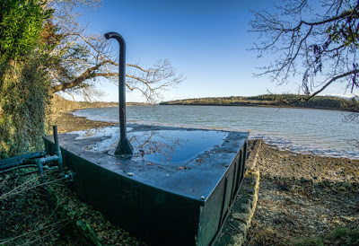
The pump-house looking towards Menai Bridge.
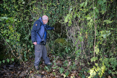
Hanging vines obscuring the overhang.
An open hole can be seen to the left of the walling, but this only appears to
extend a metre or so behind the walling.
Further walling immediately to the right of the photo above.
A fisheye lense makes this overhang appear larger than it actually is.
-------------------------------------------------------------------------------------------------------------------------
Portaway Mine Cavern
- Lost - Seen only by miners
Pantasaph
".......
a large stream of water running through a great subterraneous cavern,
in working Portaway mine in Pantasa in the parish of Whiteford, but its
discharge has never been discovered." (Pennant 1796).
------------------------------------------------------------------------------------------------------------------------
Pothole Valley Cave
- Non-existant cave
SJ20306010
Eryrys
Described
by CPAT (Report 980) in 2009. However, no cave is known at this grid
reference. The location stated appears to be the centre of a lake in the
disused Burley Hill Quarry. No cave had been documented at this location before
the quarry existed.
------------------------------------------------------------------------------------------------------------------------
Rhydlydan Rising
- Lost - filled
SJ13567350
Caerwys
This site has been filled and no trace now exists (re-visited in 2018).
It was a vertical rift 1m wide x 3m long excavated by the writer and others in
the 1970s to a depth of 5m to a flooded sump with fluctuating water levels.
At this depth the east wall veered away to form a roof with one or two
stalactites. The rift resurges in extreme floods and the land-owner claimed
that he once heard
roaring at his farmhouse (half a mile away to the north), caused by
waters issuing from the rift after exceptionally severe flooding.
Unfortunately the limestone bedding dips to the east, hence
any passage found is likely to lie below the water table. The site may
possibly have been of interest to cave divers.
From the road, walk downstream on the east bank for about 30 or 40 metres The entrance is a little above stream level off to the left a few metres past the ruins of an old cottage.
It's worth mentioning that there's a permanent spring (Ffynnon Deg) 400m further down the valley (SJ13357328)
and 500m further again there's a slot in a small outcrop where the
sound of a small underground stream (perhaps a trickle) can be heard (SJ13377280).
------------------------------------------------------------------------------------------------------------------------
Rhyd-y-Feni Cave - No such cave
Correct documented name: Cilcain Cave
Incorrectly named by CPAT in their 'Report 980' of 2009. For details, see Cilcain Cave (under Nant Gain Cave No 9)
---------------------------------------------------------------------------------------------------------------------------
Rhydymwyn Foundry Cave
- Mine passage: Entrance filled
SJ2117665440 +/-9 feet Rhydymwyn
Correct documented name: Bellan Adit
(or Bellan's Level on one old mine plan)
Not a cave, but a blocked mine adit within the perimeter fence of the DEFRA site at Rhydymwyn.
No cave-bearing rocks outcrop at this location (see Geological Survey sheets).
Incorrectly shown as 'cave' on many O.S. maps. One O.S. map wrongly marks a cave and a mine at this location.
Also incorrectly re-named by CPAT (Report 980) in 2009 as Tan-y-Ffordd Cave.
The mine passage known as Bellan Adit originally
drained the Pantymwyn vein. Its entrance was deliberately filled in the
1960s or 70s to prevent unauthorised entry, as part of the security measures taken
by DEFRA.
All that has been visible since then has been a shallow surface trench.
An informed local person has stated that it may only take a little work to regain access to the adit entrance.
Shallow surface trench; the only remaining evidence of the Bellan Adit (2012)
-------------------------------------------------------------------------------------------------------------------------
St. George Cave
- Lost - Quarried away
SH969761 ? St. George, Abergele
A resurgence cave with an active stream passage which has been quarried away or the entrance is lost beneath quarry waste. Likely to have been the rising for Dinorben Farm Sink (see page 15).
The NGR given above was the position of the cave as roughly described by a
local man:
"Oh
yes. I remember going in there with candles when I was a boy. The
entrance was in the middle of the field where the quarry now is, and it ran straight into the hill (south-west) under the
road.We could walk in for ooh 50 yards, but it gradually went smaller
and we were scared to go further because of the bats....... I used to
work in the quarry as a lad, and in 1923 we quarried down on top of the
cave and used it as a haulage way under the road, but some years later
it had to be made larger, and now there is nothing left of the cave to
see".
Source: North Wales Caving Club
newsletter No 30
(June 1975)
.
A further description is taken from "The Netherworld of Mendip" (1907) by E.A.Baker & H.E.Balch.....
"The
St. Georges Caves are situated on and about a wooded hill of limestone
near the village (of St.George)........ A great master-joint or fissure
runs across the hill......... and in it lie the caves, or rather the
cave, for so far as we could make out they are all parts of the one
stream-channel. At the top of a cliff that is now being worked for lime
in a small orifice, a mere fox's hole, blocked up against Master Reynard
or the badgers that often find a home in these small caves. A hundred
feet beneath it is a larger opening, which is said to give entrance into
several good-sized chambers; but that also has been carefully built up
with fragments of Limestone by the quarrymen. We were driven accordingly
to seek the outlet of the cave, and this we found by following the
smooth, straight escarpment, produced by the fault, in a wood close to
the main road. A large stream once issued from the cave mouth, but has
since become engulfed in some internal swallet, and emerges a few yards
lower down, welling out from a funnel of crystal water 15 feet deep. The
cave itself discharges a stream only in flood-time. There, too, we were
stopped from penetrating far by the beds of clay that gradually rose to
the cave roof; but in this instance the deposits had been made by the
stream, and were not the results of glacial action pushing upwards".
The full text from the book can be seen here:
http://www.archive.org/stream/netherworldofmen00bake/netherworldofmen00bake_djvu.txt
Today the haulage tunnel can still be seen running under the road and remnants of cave passage can be seen in the roof.
If
quarrying cut into the cave as the man described, and the cave extends
as far as Dinorben Farm Sink, perhaps the continuation of the cave can
be found elsewhere in the quarry?
-----------------------------------------------------------------------------------------------------------------------
Talargoch Cave
- Mine workings
SJ059803 Meliden
Mine workings at Talargoch Mine, Meliden
-----------------------------------------------------------------------------------------------------------------------
Tan-y-Ffordd Cave - No such cave
Correct name: Bellan Adit
S
ee under Rhydymwyn Foundry Cave above
----------------------------------------------------------------------------------------------------------------------
Tan-y-graig Vein Chamber
- Lost - Seen only by miners
SJ19645669 Llanarmon-yn-ial
Just
north of Llanarmon village is the minor lead vein of Tan-y-graig. Mine
records tell of an underground chamber encountered where ore was
washed before being raised to surface. As there are no surface streams
an active cave is a possibility, although the water table lies at a shallow depth at this location. No way into this vein has been found in modern times, although an old boy remembered an open, inclined passage leading into workings whose entrance lay on the east side of, and not far from, the road.
--------------------------------------------------------------------------------------------------------------------
Wedding Cave
- Mine workings
SJ264540 approx. Bwlchgwyn
Lead mine workings at Nant-y-ffrith, Bwlchgwyn. Several mined chambers acting as a popular venue for parties in the 60s and 70s.
--------------------------------------------------------------------------------------------------------------------
W. C. Cave
- Lost - Filled
SJ19286337 Alyn Gorge
Served as an
outside toilet for the cottage of Tan-y-Graig.
This
was a natural open rift in a field about 20 or 30 metres east of the
River Alyn. It was reported by an early resident of the property as
being 5m deep with water flowing along a narrow cave passage at the
bottom. It was in use until 1966 when the privy was burnt down and the
rift filled. The cottage is now much enlarged and provides a dog kennels service. The level of the rift entrance has been raised by several metres to provide a parking bay.
--------------------------------------------------------------------------------------------------------------------
White Quarries Caves
Four caves were lost as a result of earth moving in the 1980s. It was hoped by the quarry owner that by activating this long disused quarry, planning permission might be extended. This did not happen and the site remains inactive.
For a map showing locations of the four lost caves, and details of new caves revealed by the 1980s work, please see White Quarries Caves near the bottom of Page 9: Caves T - Z.
Lost Cave A
This
is perhaps the largest cave to have been lost. Marked 'A' on the plan on Page 9, it was entered by the writer and the late Tony Jarratt in 1974.
The
entrance was excavated to reveal a vertical drop of about 15 feet,
followed by a steep
descent into a sloping-floored chamber about 9m long x 3m wide x
2.5m high. One wonders if this could perhaps have been the lost Barnewell Cave or Grange Farm Cave, mentioned in British Caving in 1953, although there is no evidence to support this.
"By digging through rubbish, we revealed a drop of 15ft to a steeply sloping passage terminating in a roomy chamber" (Source: writers diary 20/5/1974).
The visit is also mentioned in the on-line diaries of the late Tony Jarratt: "A
rubbish-choked hole was dug to reveal a hole dropping into about 80ft
of large natural (?) rift blocked by mud and some 30ft deep at the end" (Source: http://www.mcra.org.uk/logbooks/files/JRatVol2.pdf ). There is now no trace of the cave as its entrance appears to have been covered by several tons of earth.
Lost Cave B
Length: 3m +
A previously unrecorded tube was noticed in the quarry floor in 1987 after
the quarry had been re-activated and again closed.
Marked as 'B' on the plan above,
it was a tube about 0.8m diameter running 3m to a single jammed boulder, where the way ahead continued beyond.
There is now no trace of the cave, and it is presumed to have been filled.
Lost Cave 3
Length: 5m
A crawl leads to a low passage but the entrance is nearly blocked by boulders.
No
trace of the cave was found in 2016: Appears to have been deliberately blocked by tipping.
Lost Cave 4
Depth: 4m
A narrow rift pot to a small chamber with no way on.
No
trace in 2016: Appears to have been deliberately blocked by tipping.
----------------------------------------------------------------------------------------------------------------------------------------
----------------------------------------------------------------------------------------------------------------------------------------
Appendix 1: Alphabetical list of all lost, damaged, or non-caves
List of caves
described on this page
:
Barnewell Cave: ..................... Lost
Big Wood Cave: .................... A folly
Boot Cave: ..................... Mine workings
Bryn Euryn Quarry Cave:................ Quarried away
Caerwys Caves pothole ................. Filled
Cefn Mawr Hall Cave: ................... Lost
Ceiriog Cave, Upper: .................. Entrance blocked
Clwyd Forest Cave: ................... Invented by CPAT
Coed Marl Hall Caves: .................. No passage development
Coppy Farm Cave 2: ................... Entrance blocked and lost
Dyserth Quarry Cave: ................... Quarried away
Eisteddfa Farm Cave: ................... Mine workings
Fish Cave: .......................... Mine workings
Grange Farm Cave: ..................... Lost
Gwaenysgor Cave, Lower: ............. Filled with raw sewage
Little Orme Fissure: .................. Quarried away
Llanarmon Quarry Cave: ................ Entrance blocked or quarried away
Llandegla Caves (1 of) .................... Entrance blocked
Minera Cave: .......................... Quarried away
Minera Quarry Cave: .................. Quarried away
New Passage Pot: ................... Entrance blocked by quarrying
Ogof y Gwynt: ................... Quarried away
Penbedw Park Cave: .................. New CPAT name for Big Wood Cave, a folly
Picton Mine Cavern: .................. Lost
Plas Newydd Cave: ................. No passage development
Portaway Mine Cavern: ................ Lost
Pothole Valley Cave: ................... Described by CPAT but no cave known at given location
Rhydlydan Rising: .................... Filled
Rhyd-y-Feni Cave: .................... New CPAT name for Cilcain Cave
Rhydymwyn Foundry Cave: .......... Mine workings (Bellan Adit)
St George Cave: .................... Quarried away
Talargoch Cave: ..................... Mine workings
Tan-y-Ffordd Cave: ................... New CPAT name for mine workings (Bellan Adit)
Tan-y-Graig Vein Chamber: ......... Lost
W.C. Cave ................................. Lost
Wedding Cave: .................... Mine workings
White Quarries Caves (4) ............ Filled
-----------------------------------------------------------------------------------------------------------------------
Appendix 2 List of lost sites grouped under Causes
1. Filled or blocked by landowners
Ceiriog Cave, Upper
Llanarmon Quarry Cave
Llandegla Caves (1 of)
Coppy Farm Cave 2
New Passage Pot
Rhydlydan Rising
Scouse Pot
W. C. Cave
White Quarries Caves
2. Not caves
(but mine workings or follies)
Big Wood Cave
Boot Cave
Eisteddfa Farm Cave
Fish Cave
Rhydymwyn Foundry Cave (Bellan Adit)
Talargoch Cave
Wedding Cave
3. Location unknown
Barnewell Cave
Cefn Mawr Hall Cave
Grange Farm Cave
Picton Mine Cavern
Portaway Mine Cavern
Tan-y-Graig Vein Chamber
4. Quarried away
Bryn Euryn Quarry Cave
Dyserth Quarry Cave
Little Orme Fissure
Minera Cave
Minera Quarry Cave
Ogof y Gwynt
St George Cave
5. Other
Clwyd Forest Cave: ................... New CPAT name resulting from site visit error. No such cave exists.
Coed Marl Hall Caves: .................. Perhaps a relic cave, but no apparent passage development
Gwaenysgor Cave, Lower: ............. Professional neglect: Filled with raw sewage
Penbedw Park Cave: .................. New, but incorrect CPAT name for Big Wood Cave, a folly
Plas Newydd Cave: ................. Perhaps a relic cave, but no apparent passage development
Pothole Valley Cave: ................... Described by CPAT, but no cave known at given location
Rhyd-y-Feni Cave: .................... New, but incorrect CPAT name for Cilcain Cave
Tan-y-Ffordd Cave: ................... New, but incorrect CPAT name for mine workings (Bellan Adit)
---------------------------------------------------------------------------------------------------------------------